Madison, Tennessee
1998
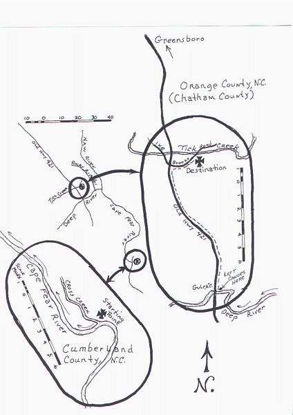
This map is by no means the exact route that John Brooks,Sr. and his six sons traveled to their land grants in Orange County (now Chatham County,N.C.) from Cumberland County,N.C..
It is an approximation that I have made by analyzing information taken from Ida Brooks Kellam's book and using the current DeLorme"s Topographical Atlas Of North Carolina.
From Cross Creek in Cumberland County, area of now Fayetteville, North up the Cape Fear River to the Deep River, thence North West to the point near Ore Hill (now Gulf,N.C.) where they landed.This is approximately seventy five miles of river travel.
Here they left their canoes. The probable trail to their land grants on the South side of Tick Creek is approximately ten miles North, assuming the trail was what is now Old Hwy 421, thence, East on present day Ike Brooks road to the point where Tick Creek crosses Ike Brooks road.
In any event, the trek to their land grants was surely an arduous journey.
I have used an arbitrary date of the trip
as
occuring in 1751, based on property transfers in
Cumberland County and new land grants to John
Brooks,Sr. in Orange
County.
Records show Thomas Brooks living in
Orange County in 1754.
Orange County Court records
lists Joab Brooks,Esq. in 1752
This date would
show the approximate ages of the
party as: John Brooks,Sr. 61,Thomas Brooks 41, Joab
Brooks
39, John Brooks,Jr. 36, Mark Brooks 31, James Brooks
26,
and Isaac Brooks 24.